Col Agnel (Colle dell’Agnello in Italian) stands at 2,744 meters as the third-highest paved pass in the Alps. This Franco-Italian border crossing offers something increasingly rare in modern cycling: genuine high-altitude adventure on quiet roads, far from tourist crowds and racing circus.
The High-Altitude Experience
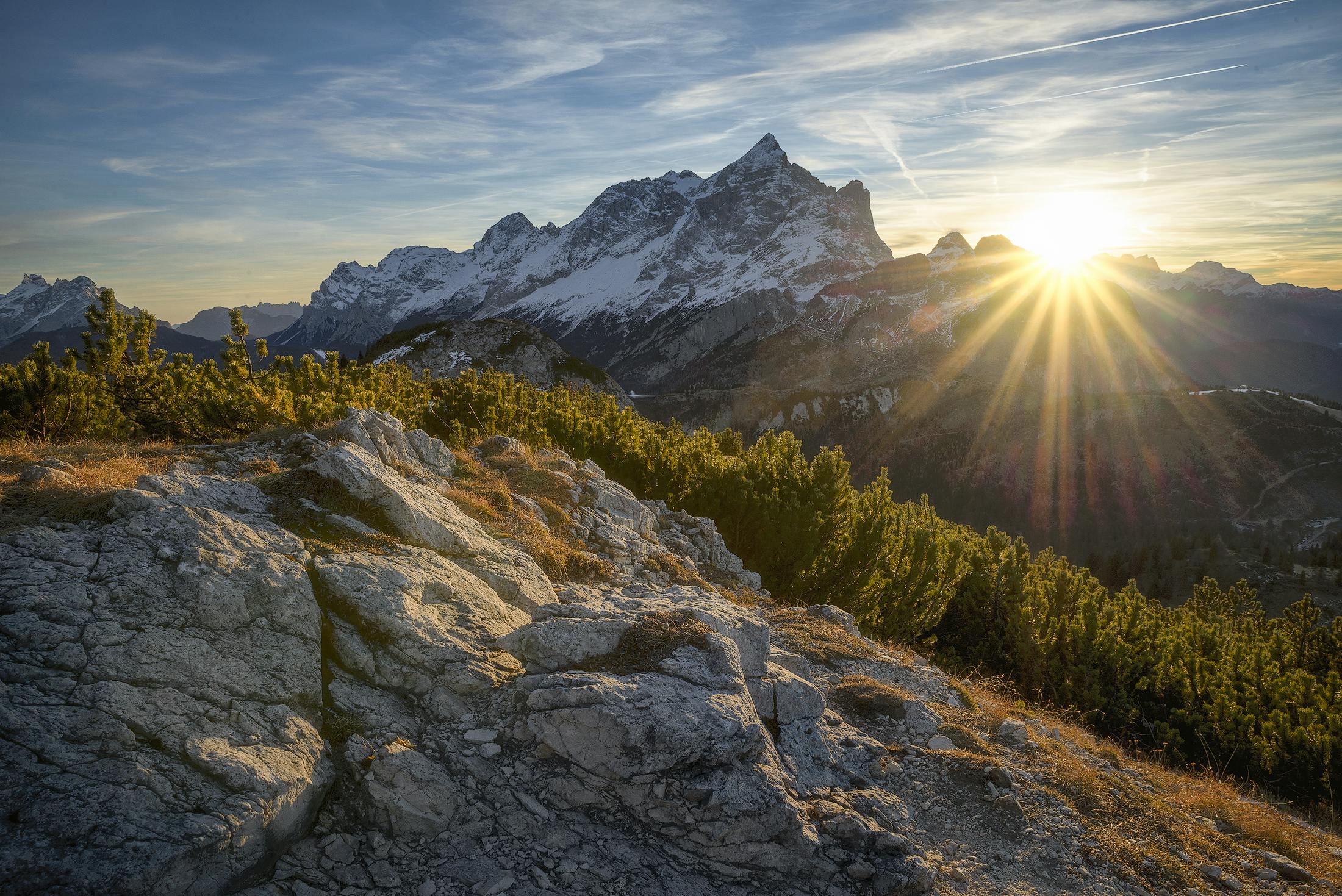
At nearly 2,750 meters, Col Agnel takes you into thin-air territory. The final kilometers climb above the tree line into a stark alpine landscape where the road feels carved from the mountain itself. The views across the Queyras on the French side and toward Monte Viso on the Italian side are extraordinary.
This altitude demands respect. The air contains about 25% less oxygen than at sea level, which you’ll feel in your legs and lungs.
Route Options
From Château-Queyras (French Side)
- Distance: 21.2 km
- Elevation Gain: 1,644 m
- Average Gradient: 7.8%
- Maximum Gradient: 14%
The French approach is the longer and more demanding option. From Château-Queyras in the Queyras valley, the road climbs relentlessly through traditional mountain villages before the final push above the tree line. The steepest sections come in the final 5 kilometers.
From Casteldelfino (Italian Side)
- Distance: 21.0 km
- Elevation Gain: 1,544 m
- Average Gradient: 7.4%
- Maximum Gradient: 12%
The Italian approach from Casteldelfino in the Valle Varaita is slightly more gradual but equally spectacular. The road passes through picturesque alpine villages with views toward Monte Viso, the highest peak in the Cottian Alps.
What Makes It Special
The Altitude: At 2,744m, only Col de la Bonette and Stelvio take you higher on paved Alpine roads. This is genuine high-altitude cycling.
The Remoteness: Col Agnel sees a fraction of the traffic of famous passes. You’ll share the road with local farmers, touring motorcyclists, and serious cyclists—not tour buses.
The Border: Crossing from France to Italy (or vice versa) adds psychological satisfaction. Starting breakfast in one country and lunch in another is pure cycling adventure.
Monte Viso Views: The distinctive pyramid of Monte Viso (3,841m) dominates the Italian side, providing a magnificent backdrop for your climb.
Tour de France History
Col Agnel made its Tour de France debut in 2008 and has appeared several times since. The 2011 stage over the Agnel into Italy saw dramatic racing in deteriorating weather. The climb’s difficulty and remoteness make it a challenging logistical proposition for the race, limiting its appearances.
Best Time to Ride
Late June through September is the typical season. Snow often closes the pass into June.
July and August offer the most reliable conditions but also the warmest temperatures at lower elevations.
Early September can be ideal—stable weather, fewer visitors, and the high-altitude autumn light is spectacular.
Weather Check Essential: At this altitude, conditions can change rapidly. Check forecasts before committing.
Practical Strategy
Altitude Acclimatization: If you’re coming from sea level, allow 1-2 days at moderate altitude before attempting Agnel. The thin air is demanding.
Pacing: Start conservatively. The altitude will catch up with you. What feels easy in the first kilometers becomes dramatically harder above 2,000m.
Gearing: A 34x32 or lower is strongly recommended. The final kilometers are steep, and you’ll be operating at reduced capacity due to altitude.
Hydration: Drink more than you think you need. Altitude increases fluid loss.
Clothing: Even in summer, the summit can be cold. Pack a wind jacket and arm warmers.
Timing: Start early. Afternoon thunderstorms are common in summer, and you don’t want to be at 2,700m when they arrive.
Summit Experience
The summit of Col Agnel is marked by a small parking area straddling the French-Italian border. The infrastructure is minimal—no cafes or facilities—which adds to the wild, remote atmosphere.
Take time to appreciate the views. To the southwest, Monte Viso dominates. To the north, the peaks of the Écrins massif appear on clear days. You’re standing on one of cycling’s highest accessible points.
The Descents
Both descents are technical and require attention:
French descent to Château-Queyras features tight switchbacks and variable road surfaces. The upper sections are exposed with no barriers—focus required.
Italian descent to Casteldelfino is longer and more flowing, but the road surface can be rough in places. The valley views are spectacular.
Combination Routes
Col Agnel works beautifully in multi-pass adventures:
- Agnel + Izoard: Cross into Italy, then return via the Montgenèvre or Échelle passes for a cross-border epic.
- Queyras Grand Tour: Combine Agnel with Col de Vars and Col d’Izoard for a comprehensive exploration of the Queyras region.
- Italian Adventure: Descend to Casteldelfino and continue to Colle di Sampeyre for back-to-back high passes.
Why You Should Ride It
Col Agnel offers something the famous passes can’t: genuine high-altitude adventure without the crowds. You’ll climb higher than most cyclists ever venture, cross an international border, and experience the Alps as they were before the tour buses arrived.
This is a climb for cyclists who value the journey over the destination, who find satisfaction in remoteness and difficulty rather than Instagram likes. The Agnel won’t give you bragging rights at the coffee shop—most non-cyclists have never heard of it. But it will give you one of the most authentic high-Alpine experiences available on two wheels.
At the summit, standing on the French-Italian border at 2,744 meters with Monte Viso watching over you, you’ll understand why some cyclists keep coming back to these quiet giants while the crowds flock elsewhere.